Updated: February 2024
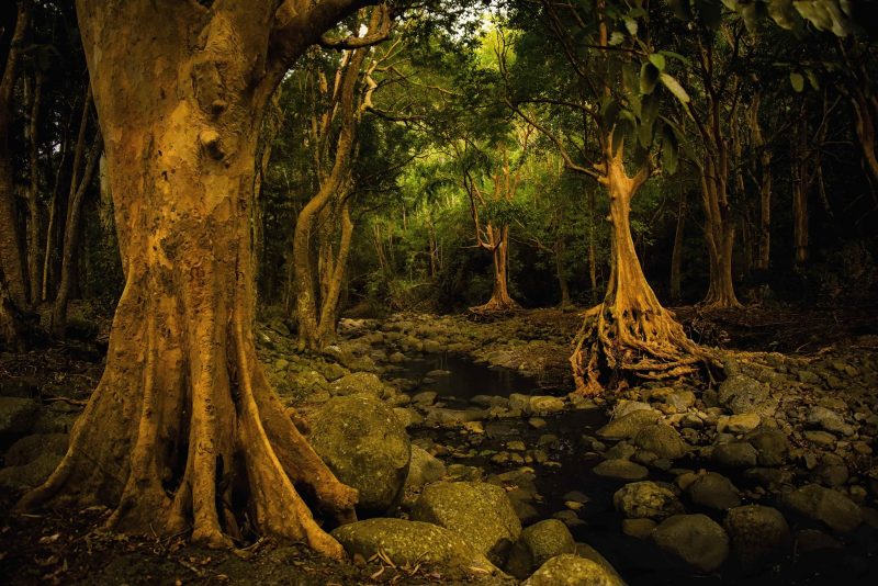
The Black River Mountain Range is one of the five mountain ranges in the Republic of Mauritius. The national park surrounding it is a popular destination for hiking enthusiasts. Home to nine species of native birds and over 300 species of native plants, the Black River Gorges National Park contains various landscapes, including waterfalls, rivers, rainforests, canyons, picnic areas, and even the mountain range itself. With over 60 kilometres of trail, the Black River Gorges National Park offers multiple hiking routes, ranging from easy ones to more challenging ones. This guide will explain everything about hiking in Black River Mauritius, starting from ways to get there, how difficult it is to trek, various routes to explore the national park, what to bring on the hike, and extra things one should be aware of when planning to hike there.
How to get there
With the national park located not far from Le Morne and Flic en Flac Beach, there are a number of ways to reach Black River Mauritius.
Rented car
You can rent a car online to drive to Black River Mauritius and drop it off at the dedicated parking space. The downside of this is that you can only hike the trails that start and end at the same entry point, and not take the ones that go through the park (west to east).
Taxi
If you want to hike across the national park without turning around, you could hire a taxi and driver to drop you off at one side, and ask them to wait on the other. It is suggested that you only pay the driver after you’ve come back from the hike.
Other alternatives
There are car-suitable roads running into some parts of Black River Mauritius. If you want to explore these before going on the actual hike, you can arrange that with the villa you’re staying at. For those who don’t want to go through the hassle of organising the whole trip, there are small-group tours available online, with time to sightsee the natural landmarks in the national park. Unfortunately, there is no bus stop at any of the entrances, therefore the national park is not accessible by bus.
Black River Mauritius Hiking Difficulty
With over 60 kilometres of trail, Black River Gorge National Park offers several routes that you can take, each presenting its own rewards and challenges. Depending on your experience, equipment, and the destination you want to reach, the routes’ difficulty levels vary from easy to moderate to strenuous. Here is the list of trails, categorised by their difficulty level.
Easy: Les Mares Trail
Easy-moderate: Trochetia trail, Cascade 500 Pieds, Mount Cocotte, Macchabee Trail Viewpoint, Piton Savanne, Plateau Remousse View Point
Moderate: Black River Peak, Macchabee Forest Loop Trail, Brise Fer Mountain, Mare Longue Loop Trail, Mare aux Joncs Waterfall (bottom part)
Moderate-strenuous: Parakeet Trail, Alexandra Falls
The Journey – Hiking trails in Black River
This guide will list a few of the hiking trails available at Black River Mauritius.
Trochetia Trail
This trail’s total distance is 2 kilometres, and it takes 45 minutes to complete it. One of the easy-moderate level trails, it is mostly flat but muddy. The starting point is on the right side of the Gorges Viewpoint. After 15-20 minutes of walking the trail, you will reach a river. To continue the trail, walk across the river. If you turn left and walk along the riverbed, you will reach the top section of the Trochetia Waterfall. Just be aware that the rocks are slippery, and do not go too close to the edge. After crossing the river, there’s an intersection: turning right brings you to Plaine Champagne Road, while turning left brings you to the Gollum Trail. This one is very strenuous and should not be attempted without an experienced guide and proper equipment.
Black River Peak
Adding up to a total distance of 6.6 kilometres, it takes about 1.5 to 2 hours one way, depending on the starting point. The trail, also known as Piton de la Petite Rivière Noire, is a moderate-level one. Starting point is 400 metres from Gorges viewpoint, so one can drop their car off there. The main destination is the Black River Peak, which has views of its river bay, La Morne Brabant, and La Tourelle du Tamarin. The journey isn’t too challenging, until you get closer to the summit (the path gets steeper). With the last section of this hike, you are faced with two choices: one, is to scale up the steeper part, using the tied rope, straight ahead. If that is too strenuous, you can turn right, which houses a new, less slippery path to the summit.
Parakeet Trail
This 8-kilometre-long trail is one that goes from one point to another (no return). The points are the Black River Visitor Centre and Plaine Champagne (50 metres from the police post). It is a moderate-to-strenuous trail, taking around 3 hours to complete.
Alexandra Falls
The moderate-strenuous trail takes 10 to 15 minutes one way. One of the more popular trails, there is a trail connecting to this that allows you to hike down the waterfall, but an experienced guide is needed to help you attempt it, as it is very steep.
Cascade 500 Pieds
Taking 30 minutes to complete one way, the total distance of the path is 4 kilometres. It is an easy-to-moderate hike, where you will be rewarded by a wonderful view of the south coast of Mauritius. It is also home to a natural infinity pool. One you reach the top, the hike stops there. If you want to go on the descent, you need a guide to help you.
Mont Cocotte
The total distance of the path is around 4 kilometres, taking 30 minutes to complete one way. Its level is easy-to-moderate, and it is also the shortest trail. The path is easy to follow, but it does go steeper as one approaches the summit. Starting from Alexandra Falls Viewpoint, go to the path opposite the map sign of the whole national park. Go straight ahead for 20 to 25 minutes, there is a tree on your right that is painted with red paint. From there, go to the narrow path, surrounded by tall pine trees, until you find an intersection. Turn left and continue until you get to the summit, which offers two viewpoints; one across from the trail exit and another is on its left.
Macchabee Forest Loop Trail
This is a moderate-level trail, taking 3 hours to complete the entire 8 kilometre distance. The trail goes through Macchabee forest, Mare aux Joncs Waterfall, and then back to Petrin. The markers for this trail is coloured purple. You will reach the first viewpoint after 15 minutes. There are more viewpoints after this one. You can choose to go straight ahead or turn left. If you go straight ahead, you will reach the Mare aux Joncs Waterfall via a mostly-flat trail that goes into a slight descent halfway through. The hike gets more challenging as you complete the second half of the loop, as the incline becomes more steep. After an intense 20 minute walk, you are exiting the Macchabee forest and into the Macchabee trail, where you are once again faced with options; the right trail to get to Macchabee Viewpoint (takes 15 minutes to do), or the left trail to go back to Petrin Information Centre.
Machabee Trail Viewpoint
Covering a distance of 10 kilometres, this trail takes around 1 hour one way. Depending on where one starts their hike, the path ranges from easy to moderate. The route is a favourite one among the hikers. It is advised that you should start this hike from Petrin Information Centre, as it is already higher up in elevation. Follow the signs for Macchabee Trail, until you reach an intersection. Turn left, then keep going ahead until you reach the Macchabee kiosk. The views that come with this hiking trail are of: the Gorges, Tamarin Bay, and Tourelle du Tamarin. On the way back, one can opt to go back to Petrin, or follow the path to Black River Visitor Centre.
Les Mares Trail
If you are getting your kids started on hiking, this 8 kilometre trail is perfect for you. Taking 1 hour (one way), it is a relatively easy hike, with not many other hikers around. Starting point is at Petrin Information Centre. Follow the sign of Les Mares Trail, until you encounter an intersection about three quarters of the way there. To finish the hike, turn left to the Le Mares Roundabout. Turning right brings you on the way to Plain Champagne Waterfall, which should take about 15 minutes. Be cautious when going this way, because the path is muddy.
Piton Savanne
At a total distance of 6 kilometres, it takes 1.5 hours to do one way. A beautiful view of the southern coast of Mauritius awaits you upon completion of this trail. Easy-to-moderate level, the starting point is about 3.5 kilometres from Petrin Information Centre, somewhere on the B102 Road to Chamouny. Most of the hike is easy, until you get closer to the summit, then you have to use your hands and feet to ascend the steep incline.
Brise Fer Mountain
A moderate-level hiking trail, it is the longest trail, with a total distance of 14 kilometres covering it. It takes 2 hours to cover one way. Starting at Petrin Information Centre, it goes through Macchabee Forest Loop Trail, the merge with Mare Longue Trail. Continue along the latter, until you see a metal gate at the intersection. Turn left to reach the summit, via a gradually-sloping path.
Mare Longue Loop Trail
It takes 4 hours to complete this 12 kilometre trail, as it’s a moderate-level hike. It starts from Petrin Information Centre, through the Macchabee forest and to the Mare Longue Reservoir. One has to be relatively fit to take this path, because although it has little elevation change, it is still a long trail.
Plateau Remousse Viewpoint
It takes 45 minutes to complete one way, as it is an easy-moderate path. It is considered as the most scenic hiking route one can take, allowing you to view the forests, hills, and mountains. Start at the Black River Visitor Centre, go into the forest until you come across an intersection with a sign showing the way to the Macchabee and Plateau Remousse. Follow the trail until you get to a river and a bridge, go across the bridge, turn left towards the hill. First checkpoint is on your right. Keep going straight ahead until you come across a sign pointing the way to Plateau Remousse Viewpoint, turn right to reach the viewpoint.
Mare aux Joncs Waterfall (the lower section)
It is a 6 kilometre long, moderate-level trail, taking 1.5 to 2 hours to complete one way. Start from Black River Visitor Centre, follow the signs until you reach an intersection, follow the sign to the Mare aux Joncs Waterfall. Turn left, and then follow the green and orange signs. The path gets steeper as you get closer to the bottom of the waterfall.
What to bring on your hiking trip
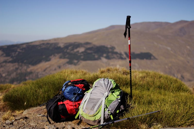
No matter if you take the easier hiking trail or the more challenging ones, here is a list of essentials to bring when venturing the Black River Mauritius.
1. Maps
An offline map application like maps.me is more preferable when hiking on the mountains of Black River Mauritius. One can also print a high definition map of the trails (found online), or obtain one from an information centre.
2. A good pair of hiking shoes
If you only plan to walk on the less strenuous trail or have picnics by the entrance points, good running shoes are adequate. But for those planning to hike, trekking shoes are a must.
3. Food and water
If you plan to hike for more than an hour or take the more challenging hiking route, you should bring enough food and water to last you the journey. Not drinking enough water while doing a strenuous activity will lead to dehydration and confusion. Food is needed so you can replace the lost energy.
4. Mosquito repellant
Some of the paths at the Black River Mauritius are muddy because the sun doesn’t go through the thick canopy of trees. These provide a good environment for mosquitoes to survive, especially during the rainy season. So, it is essential to bring a mosquito repellant.
5. Hat and sunscreen
Although most of the park is covered by forests of trees, it is still wise to wear sunscreen and a hat when hiking at the park. This is because although sunshine couldn’t reach parts of it, the ultraviolet rays do. A hat protects you from getting a heatstroke, especially during the warmer months.
6. A change of clothes
If you plan to hike during the colder season, some of the trails get very muddy and more slippery to walk or climb on. Make sure to bring a change of clothes so you can change back after finishing the hike. Make sure to wear a jacket and warm clothes, as the mountain climate makes the temperature at the park colder than in other parts of Mauritius.
7. Cash
This is self-explanatory if you are travelling to Black River Mauritius by taxi. Even if you aren’t, it is suggested that you should have cash on hand in case you might come across a few kiosks on your trip/hike (by car or on foot) that sell rare local sweets specific to the area. At the information centres, you can donate for the upkeep of the facilities of the park.
Things to take note of
Before you set off to Black River Mauritius, here are some things you need to know about the national park.
Entrance fee
As of 2024, there is no entrance fee imposed by the national park.
Fenced off area
Black River Gorges National Park has boundaries separating the trails from the protected wildlife areas. It is essential that you do not go further into these areas on foot, and only pass through by car.
Entrances
The national park has a number of entrances: La Marie, Black River, Case Noyale, and Chamouny. To get to the start of the hiking trails, there are four access points: Gorges Viewpoint, Alexandra Falls Viewpoint, Le Petrin Information Centre, and Black River Gorges Visitor Centre. All four access points have facilities such as toilets, picnic areas, and parking spaces. The last two, the Information Centres, usually have physical maps of the Black River Mauritius. Le Petrin Information Centre even has a scale model of the park.
Accommodation
The location of the national park is about an hour’s car trip from Flic en Flac beach and Le Morne, so there’s no need to stay overnight. However, if you do want to, accommodations are available in Chamarel, the village inside the park.
Check out our villas in Mauritius